Today I enjoyed the outdoors. I chose to carry......

Not today but yesterday. Our Dove Season opened yesterday morning and I carried and shot my Benelli Super Black Eagle.
I'm just going to be the guy that comes out and says it. The only reason they even ask what firearm you were carrying is to keep it within the parameters of this forum. We want to see the outdoors pictures
 
Last edited:
Same Walther PPS but different 1791 holster. This time it's a 4way version that I took the metal spring type clip off since it never really worked as an IWB choice. The holster refused to stay in the waistband when drawing and always wanted out to see what was happening. A case of retention exceeding grip.

PPS-1791-2.jpg

6:09pm and still 100F.
 
I'm just going to be the guy that comes out and says it. The only reason they even ask what firearm you were carrying is to keep it within the parameters of this forum. We want to see the outdoors pictures
Why yes, yes we do want to see outdoors pictures from around our beautiful country.

I went into my backyard today. It's occasionally cloudy and sometimes rains up here.

backyardxx.jpg

But this is what my back acre looks like when it's sunny

mowing.jpg

As I live in the woods, I always carry protection. I have a designated backyard gun, of course (doesn't everyone?).
King Cobra.jpg

But today the grass was too wet to mow, so I gave up and at 5:00 pm sharp: (RIP Jimmy Buffett, we shall miss you!)
it's 5 oclock somewhere.jpg
 
Garden of the Gods FB_IMG_1694045858428.jpg
Not my photo.
20230906_125448.jpg
My photo area of detail under red dot.
20230906_124819.jpg
My Benchmade Bugout.
20230906_113014.jpg
Galloway Homestead Rockledge Ranch.
20230906_113056.jpg
A fire pit outside the cabin. I was standing behind it when I took the photo of the cabin.
20230816_095838.jpg
Compliance shot
20230906_114255.jpg
Smoke in the air. Pikes Peak.
20230906_115411.jpg
Wyoming Indian Paint Brush.
20230906_113347.jpg
Walking through the forest
 

Attachments

  • 20230906_113056.jpg
    20230906_113056.jpg
    252.3 KB · Views: 1
Todd Begg Mini Bodega, manufactured by Reate from a few years ago.

I’ve wanted a Begg design for a long time. Wonderful little 3” S35VN blade.

Got a fantastic price too. I need to open her up and clean out the pivot, but otherwise perfect.


IMG_2733.jpeg IMG_2732.jpeg IMG_2730.jpeg IMG_2731.jpeg IMG_2734.jpeg
 

Attachments

  • IMG_2732.jpeg
    IMG_2732.jpeg
    235.1 KB · Views: 0
  • IMG_2729.jpeg
    IMG_2729.jpeg
    199.5 KB · Views: 0
We love the knives! I'm a little afraid that I would trash them as a woods/hiking/edc knife!!!
I hope you get out to enjoy the outdoors this weekend!
I work in an office now so edc is ok for them. But if I’m going to the woods I bring one of these. Both expensive knives but they are my users.

Though as you can see, they are very cared for.

And then either a Sig or SA 10mm.

I’ve ditched almost all my super common guns now.

IMG_2564.jpeg
 
Last edited:
Sunday out at the hunting property. My usually Model 10 pleaded illness (cough cough :rofl:) I suspect it realize I was going to be on the tractor most of the day and it didn't want to get all dusty again. So I drug out my old war horse. A 1916 Webley Mark VI. After finishing the plowing and planting of our last three food plots I went for a short walk and did some metal detecting. Didn't fine anything but a few more really old shotgun shell bases but it was a nice evening for a walk.

PXL_20230910_224051444.jpg
Got go armed, you never know when a gang of up armored opposume will try to jump me again. I was lucky today no attacks.

PXL_20230910_212325767.jpg
This food plot was planted three weeks ago. We go rained out about half way through planting our plots that day and this weekend was to finish that up. For three weeks growth we were pleased with this. It's mostly just oats and some turnups and radishes mixed in.
 
Last edited:
North Cheyenne Loop.

20230912_092203.jpg
I did a Loop in North Cheyenne Cañon Park on Sunday. 15.5 miles I'm not sure exactly how you would compute the elevation gain but I started at Helen Hunt Falls Red Dot and hiked up to Mount Muscoco (1500 feet) then I went down to Mount Cutler and back down to the road(830 feet decent). Then I crossed the road and got on the Creekside Trail and took the mid Columbine Trail back to Helena Falls. According to the map from the road to the top of the mid Columbine Trail is 1600 ft and then I walked back down to my car at Helen Hunt Falls. I don't know how you would compute the elevation game but it took 8 hours and kicked my ass.

So I started at the Red Dot, I took the gold colored Trail Bruin up to where it meets the Black colored Trail (Blue Dot). Then they took the black colored Trail to where it meets the red and white polka dotted Trail and walked to the 1. I walked from the one to the 4 on the black dotted Trail. (The black dots supposedly signify that it's not an official Trail but it certainly appears to be maintained to me). Once I got to the four I took the maroon colored Trail over the shoulder of Mount musco and down where it meets the green trail. I turned right and walked on the green trail to the top of Mount Cutler (number 2).

From the top of Mount Cutler I walked down to the yellow Dot, across the creek and I took the black dotted Trail to right under the C in Mid Columbine on the blue and white polka dot Trail.

So they took the blue and white polka dotted Trail all the way back to the Bruin Picnic area and walked the last 100 yards or so on the road.

I would like to point out that I did all that and never left the city park. Colorado gets a lot of things wrong but Parks and Rec is not one of them.

And here are some random photos that I took

20230910_111141.jpg
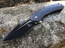
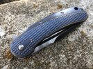
Compliance Shot Buck 110, Glock 19, Stick and Stylish Tilley Hat.
20230910_110829.jpg
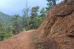
This was coming Down Mount Muscoco. I put this picture here because that's where I happen to take my compliance shot

20230910_081836.jpg
This is where I started. I parked at the head of that staircase walked down it, crossed the bridge and got on Bruin.
20230910_100833.jpg
I took this picture right where the Broom Trail meets the Daniel's Pass Trail. The Red Dot is where I started.

20230910_101010.jpg
This is looking West From Daniel's Pass to North Cheyenne Cañon.
20230101_092038.jpg
I didn't take this picture on this hike but this is standing on top of that Granite wall looking East towards Daniel's Pass.
20230910_120935.jpg
This was standing on kind of the north side of Mount Cutler looking at Cheyenne Mountain.

20230910_111159.jpg
This is actually looking back from where I took the compliance shot at Mount Muscoco.
20230910_123407.jpg
This is standing on Mount Cutler looking Southwest Down Sweetwater Canyon.
Part Two next post
 
Last edited:
North Cheyenne Cañon Loop Part Two.
20230910_123503.jpg
This is walking down to mount Cutler Trail. I'm actually looking Northeast here and I'm pretty sure that Ridge is in North side of Bear Creek Cañon.
20221211_150955.jpg
This is standing on Mount Cutler looking at Sweetwater Cañon.
FB_IMG_1664823042318.jpg
This is standing on top of Kineo Mountain looking down Bear Creek Cañon. Loud's Cabin is down in that Cañon.

The point I'm trying to make with these photos is all three of these Canyons connect and it's all  ONE City Park.
20230910_124657.jpg
This is the Mount Cutler Trail looking East at Colorado Springs.

20230910_131855.jpg
This is on The Creekside Trail


I was standing on those rocks when I took that video.

20230910_151459.jpg
Mid Columbine Trail. 20230910_134504.jpg
I stopped and leaned on a rock and this little dude ran right over my hand.
20230910_161323.jpg
Looking at Colorado Springs.
20230910_162316.jpg
Almost Done. The trail to the Left leads back down to the Bruin Picnic area.

I'm not going to do a whole another post for the last two pictures
 

Attachments

  • 20230910_160642.jpg
    20230910_160642.jpg
    227.6 KB · Views: 2
Last edited:
Back
Top